Serving the New Orleans Metropolitan Region
Our Job
The NORPC is a group of local elected officials and citizen members appointed to represent you on regional issues, like the environment, transportation, and economic development.
We engage with the community and plan for the future.
Building the Road to a Better Region
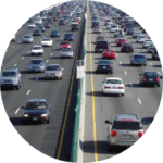
The Regional Planning Commission is committed to the people of south Louisiana. By focusing on the key aspects of sustainable growth in the region, we help maintain a healthy environment and streamline transportation, while driving economic development.


Get Involved
Join a Coalition
Announcements
Regional Planning Commission February 13, 2024
AGENDA
MEETING CANCELLED DUE TO MARDI GRAS HOLIDAY.
RPC Launches Future St.Bernard Transportation Study
Click Here to learn more about the project, participate in online surveys, and plan to engage in future outreach events!
Public Participation Plan 2024 Available for Review and Comment
The Regional Planning Commissions draft Public Participation Plan is now available for public comment. Comments will be accepted beginning January 9th, 2024 and conclude March 9th, 2024. Comments can be left HERE or sent directly to Malissa Givhan at [email protected].
FHWA/FTA Certification Review – Final Report Available
On January 31-February 1, 2023, the Federal Highway Administration (FHWA) and the Federal Transit Administration (FTA) facilitated the certification review site visit meetings to discuss the transportation planning process for the New Orleans urbanized area (UZA), as conducted by the Metropolitan Planning Organization (MPO). FHWA and FTA are required to jointly review and evaluate the transportation planning process for each UZA over 200,000 in population, known as a Transportation Management Area (TMA), at least every four years to determine if the process meets Federal planning requirements.
Full report can be found below:
Explore Our Resource Library
Browse our resource library for access to hundreds of studies, data, maps, GIS files, and more.