Regional Overview and Data

The Region

The RPC’s region comprises approximately 4,000 square miles of land and 4,700 square miles of water across eight parishes: Jefferson, Orleans, Plaquemines, St. Charles, St. Bernard, St. John the Baptist, St. Tammany, and Tangipahoa. The combinations of these parishes vary depending upon which designation we are representing.

Population Density

Approximately half of the non-water geographic area is marsh soil, leaving only 1,000 square miles of solid land. Of the readily developable land, the average population density is approximately 1,200 persons per square mile; however, more densely populated urban areas average nearly 3,900 persons per square mile.

At a Glance

Planning Geographies

Population

The region’s population has experienced significant changes during the last 50 years. The population increased dramatically during the 1960s and 1970s, primarily due to the growth of the oil and gas industry. In the early 1980s, the region encountered a significant decline in population, attributed to the oil bust. Prior to Hurricanes Katrina and Rita in 2005, the region maintained a population of approximately 1.3 million. Katrina and Rita amplified pre-existing shifts in population: Orleans, Plaquemines and St. Bernard parishes endured dramatic population losses, whereas St. Charles, St. John, St. Tammany, and Tangipahoa parishes gained residents. The current population of the region is approximately 1.4 million.

Copy of Total Population of the Greater New Orleans Region

AreaCensus 1990Census 2000Census 2010Census 2020
Louisiana4,219,9734,468,9764,533,3724,657,757
Jefferson448,306455,466432,552440,781
Orleans496,938484,674343,829383,997
Plaquemines25,57526,75723,04223,515
St. Bernard66,63167,22935,89743,764
St. Charles42,43748,07252,78052,549
St. James20,87921,21622,10220,192
St. John the Baptist39,99643,04445,92442,477
St. Tammany144,508191,268233,740264,570
Tangipahoa85,709100,588121,097133,157
TOTAL1,370,9791,438,3141,310,9631,405,002
The above figures show the comparison between the 1990, 2000, 2010 and 2020 official U.S. Census population figures for parishes in the New Orleans region. Prepared by the Regional Planning Commission for Jefferson, Orleans, Plaquemines, St. Bernard, St. Charles, St. James, St. John the Baptist, St. Tammany, and Tangipahoa Parishes.

American Community Survey 2023 – Regional Tables

(2019-2023 – 5 Year Estimates)

Limited English Proficiency by Parish

Race and Ethnicity

Poverty and Median Household Income

Employment and Unemployment

Elderly and Age by Category

Education Attainment

Disability by Category

Limited English Proficiency Household

Vehicles Available for Travel to Work

Citation:

GIS – Downloadable Census Files

ACS 2023 (19-23 5YR Estimates) – LA Census Tracts
ACS 2023 (19-23 5YR Estimates) – LA Block Groups

Imaging

LiDAR Icon

LiDAR

Elevation data is obtained via optical remote sensing technology, known as Light Detection and Ranging (LiDAR). LiDAR allows for the measurements of distance. The United States Geologic Survey (USGS) provides LiDAR datasets that are available for download at the USGS LiDAR Explorer website.

Helicopter Icon

Ortho Imagery

High resolution imagery ranging from three-inch to one-foot pixel is used throughout the region to provide an accurate background for line work being produced through local efforts. High resolution imagery can be downloaded from the United States Geological Survey (USGS).

Elevation

National Geodetic Survey (NGS) Data Explorer and the Louisiana Spatial Reference Center (LRSC) also provide information on bench mark elevations and additional Global Positioning System (GPS) sites in coastal Louisiana for the area south of Interstate 10.

Louisiana Map

Geographic Information Systems

The RPC facilitates the development of data sets for GIS use through cooperative endeavors with federal, state and local agencies. The RPC provides data to local governments and facilitates local data sharing. Published data, maps, and interactive applications can be found on the RPC Mapping Resources webpage. 

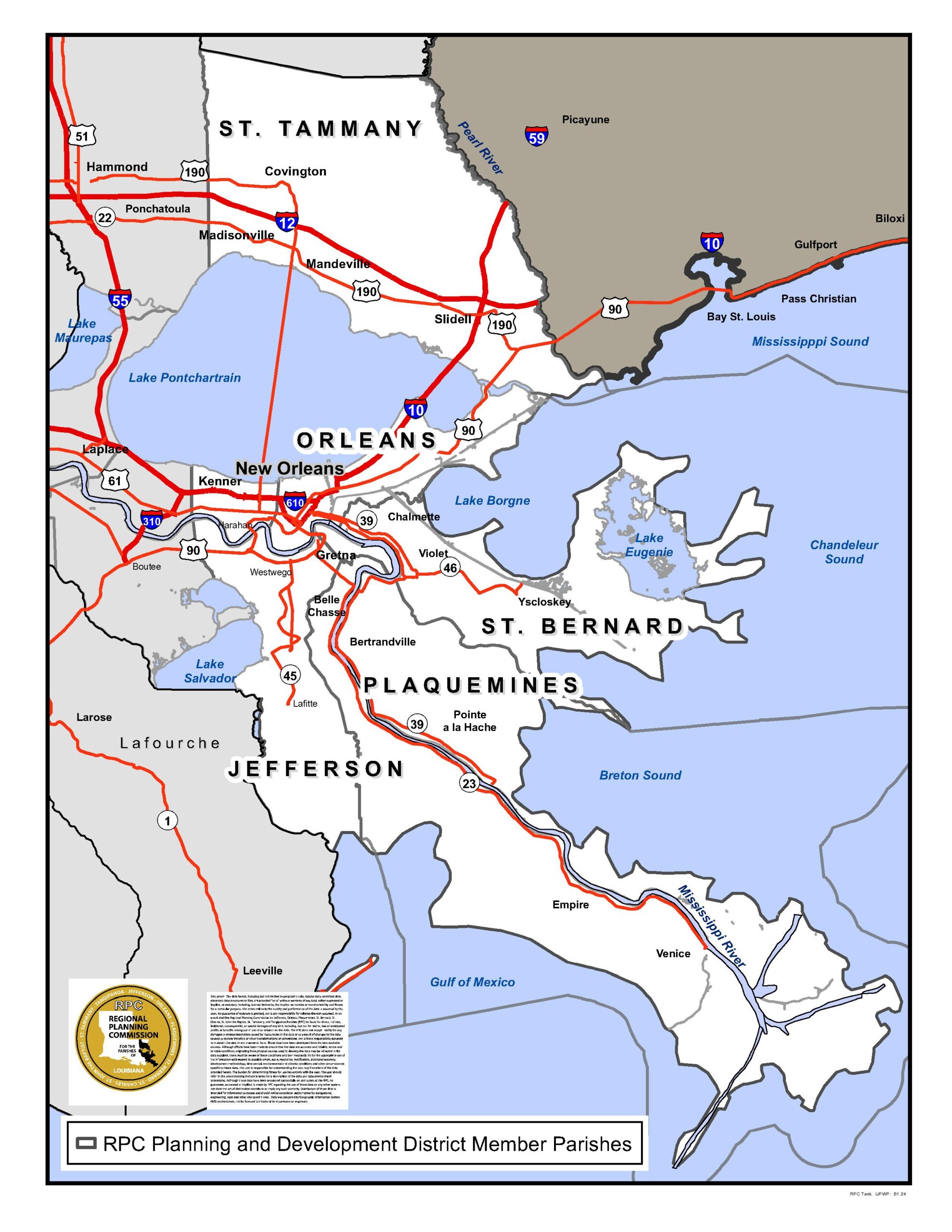
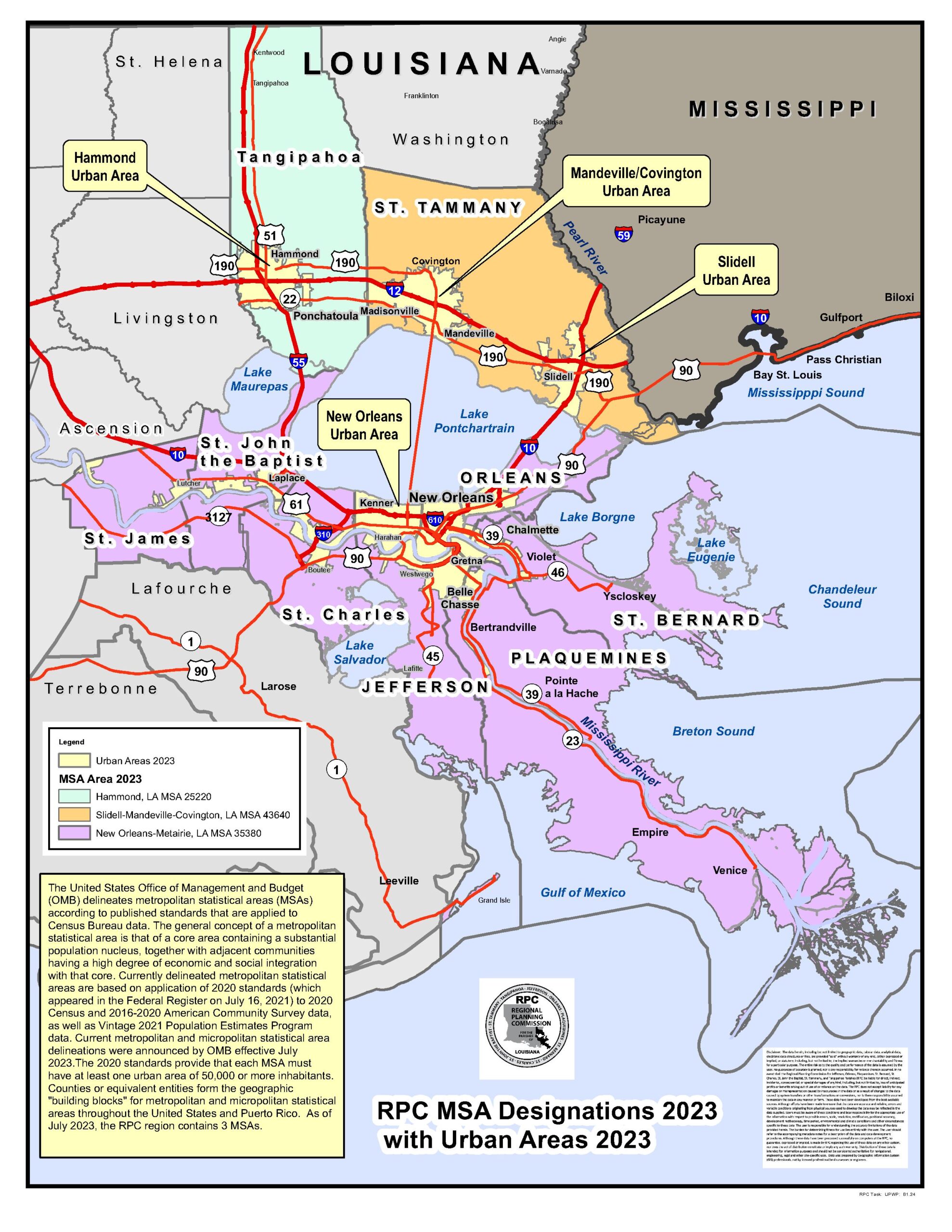
Applied Community Statistics

RPC develops and provides data-driven insight into regional conditions across Southeast Louisiana. Using sources such as the U.S. Census the program tracks key community indicators—population trends, housing affordability, transportation access, and economic opportunity.

RPC, produces regionally scaled data frameworks including Title VI, NEPA Awareness, Social Vulnerability Index, and more.  These measures help identify areas of need, monitor change over time, and support equitable planning and policy decisions across the region.

Economic

The RPC, as part of it’s Economic Development program develops regional economic frameworks using EMSI and other data sources to analyze industry composition, workforce trends, job density, and commuting patterns. These indicators help monitor economic change, identify growth opportunities, and support coordinated regional planning and investment strategies.

Environment

RPC, compiles regional data on land cover, vegetation, flood risk, coastal restoration, and more to better understand the natural systems that shape Southeast Louisiana. These indicators help track environmental change, support resilience and adaptation planning, and guide strategies that protect natural resources and enhance community sustainability.

TRANSLATE