Lower St. Bernard Parish, LA Roadway Network & Resilience Study

The Regional Planning Commission (RPC), along with the Port of New Orleans (Port NOLA) and St. Bernard Parish, is conducting a “Stage 0” Feasibility Study. Together, we are checking on how changes in transportation in lower St. Bernard Parish, like more industry and a new Port project in Violet, might affect the Parish and how to make transportation better for the Parish and the Port project. The planning process includes public notice that the planning products produced in the planning process and study may be adopted during a subsequent environmental review process.
The RPC Study has a larger focus than what Port NOLA has been studying, including if there are ways to handle the extra traffic and jobs that will come to lower St. Bernard Parish because of the new Port NOLA project, as well as other projects down the river. We are also working to ensure this effort meets future federal requirements regarding community engagement, and supports the needs of the Port, St. Bernard Parish, and the whole region over time.

The Louisiana International Terminal (LIT) Project
Port NOLA is planning to build a new container terminal called the Louisiana International Terminal (LIT) in Lower St. Bernard Parish. This terminal will cost about $1.5 billion and is expected to eventually handle around 2 million containers every year. The Port chose Violet as the location because it has deep water, is close to railroads, and is protected by levees. Port NOLA has already bought around 1,200 acres of land in Violet for Port operations, and the actual terminal area will be about 400 acres. The Port has started the process to get the necessary permits from the U.S. Army Corps of Engineers. You can find more information about this project on their website: louisianainternationalterminal.com.
II. Who Does It Impact?
The Study area includes all of St. Bernard Parish, LA, with a focus on understanding how everyone gets around, including people who may not be fluent in English, people over 65, people with disabilities, those without cars, or anyone who finds it difficult to travel.
We want everyone to have the opportunity to tell us what they think about the transportation network (i.e.; roads, rail, and bridges) and how future projects should be designed to best support the community. We’ve set up different ways for you to participate to support this goal, including online surveys, in person and online community meetings.

III. Timeline

IV. How to Stay Informed and Get Involved
Second Community Meeting Scheduled for June 5, 2024
Join the RPC for the second public meeting on this Study.
Date: Wednesday, June 5, 2024
Time: 5:00 p.m. to 8:00 p.m.
Place: St. Bernard Parish Government Complex
Address: 8201 W. Judge Perez Dr, Chalmette, LA 70043
This meeting is free and open to the public.
Review the Outreach Plan!
Our Outreach Plan is a way to make sure we hear from everyone right from the start of the study. We want to know what you think and include your opinions as we look into new transportation plans for St Bernard in response to a new Port terminal. It’s important to us that everyone has lots of chances to join in and help shape the future. Are you curious about how it all works?
Click here to learn more and see how you can be a part of the Study.
Take the Community Survey!
The Community Survey is designed to gather input on transportation-related issues and needs in St. Bernard Parish to plan for the future of transportation in St. Bernard Parish, with a focus on addressing the needs and challenges faced by residents as a result of a new Port site in Violet. It can also assist in developing policies and projects that enhance overall transportation accessibility, safety, and efficiency.
Mark the Map!
Your feedback is crucial to shaping transportation policies and projects that can best serve the needs of the people in St. Bernard Parish. Before you Mark the Map, please note the following for your awareness:
- Purpose: The primary purpose of the survey is to gather input on three main aspects: things people love about the area; roads, bridges or railways that need improvement; and ideas for transportation improvements.
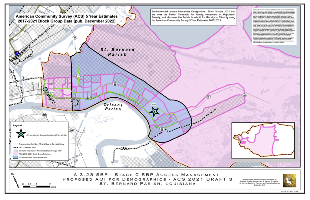
- Specific Focus: The “Star” on the map represents the planned Port NOLA LIT site. This could be a significant transportation development, so we’ve highlighted it here as a focal point for gathering feedback.
- Supporting Infrastructure: We’ve highlighted existing transportation corridors and the railroad network on the map to help participants see the existing roadway network and identify potential areas for improvement.
- Video Demo: A video demo is available to guide participants on how to submit a mapped comment. This can be
V. Common Questions and Answers
A1: This study considers how St. Bernard is growing and changing, and is checking to see if the transportation system—like roads, sidewalks, and bridges—works well for people today and will keep working in the future. The study also looks at ways to reduce or mitigate the potential impacts of the Port of New Orleans Louisiana International Terminal (LIT) Project.
Community impacts considered include how proposed project transportation solutions could impact: (1) new and current housing areas, (2) emergency vehicle access for police or firefighters, (3) evacuation routes, (4) connectivity between Orleans and St. Tammany Parishes, (5) long-term growth, (6) access to local business, and (7) industry access to warehousing and supply chains.
A2: It’s about more than the Port of New Orleans Louisiana International Terminal (LIT) Project. While the study will focus on reducing negative effects from the Port’s potential terminal, it will also help plan for the future growth and needs of the Parish to make the community stronger and more efficient.
This study might lead to more money from the federal, state, and local governments to make the transportation network better, so emergency services can respond faster, the community can bounce back from challenges, and people can get to their jobs more directly.
A3: 80% of this study is paid for with federal dollars allocated to the Regional Planning Commission for transportation planning purposes and 20% is paid from funding allocated to the Port by the State legislature. The Port of New Orleans’ role is to provide relevant information to the RPC related to freight movements of the proposed downriver terminal in Violet, La.
A4: Major construction is years away. Right now, we’re counting how many cars, trucks, train cars, pedestrians and bicycles usually operate in the area. From this we will estimate how this traffic may grow, and how many more businesses or people it may attract. That information will support development of different project solutions or alternatives to respond to traffic. After careful consideration and community engagement, some ideas will be kept and others will be set aside. Further analysis will be completed by the Louisiana Department of Transportation and Development (LA DOTD) after the Study is complete to make a final decision on whether or not a project solution will be constructed. If selected for construction, LADOTD will create a cost estimate for engineering design. Funds for a project must be dedicated before construction begins. We’ll have a better idea of when construction could potentially start after these steps.
A5: The Study will take about 10 months. It started in October 2023 and should be finished around July 2024.
A6: We want to hear from you and make sure everyone has a chance to share their thoughts on future growth and development in the Parish. You can participate now by taking the community surveys (linked above). There will also be two community workshops tentatively planned for April and June 2024. Sign up for our mailing list to stay informed of the exact date and location of these meetings and other events, which will be released in the coming months.
Sign Up for Updates
Sign up for our Listserv to stay informed of project updates.
Translation Support Services
If you require translation support services, please contact [email protected] and we will be in touch!
Si necesitas servicios de apoyo en traducción, por favor contáctanos en [email protected] ¡y estaremos en contacto contigo!
Nếu bạn cần dịch vụ hỗ trợ dịch thuật, vui lòng liên hệ với chúng tôi tại [email protected] và chúng tôi sẽ liên hệ với bạn!
Please note that information collected in support of this Study may be used in a future NEPA Process.
