“Metropolitan transportation planning is the process of developing coordinated strategies to address the long-term and short-term transportation needs of a broader geographic area, known as region, encompassing multiple municipalities and parishes. Unlike local planning, which focuses on individual jurisdictions, regional planning looks at the bigger picture—how people and goods move across a region and how transportation supports broader goals like economic growth, environmental preservation, and community needs.”
Metropolitan Transportation Planning – 2056 Update Underway
What is the Metropolitan Transportation Plan?
“The Metropolitan Transportation Plan (MTP) is the long-range blueprint for our region’s transportation system, guiding investments and policies over a 30 year horizon. The planning process is comprehensive, cooperative, and continuing, as required by federal law, and is led by the Regional Planning Commission serving as the Metropolitan Planning Organization (MPO) for the region, in coordination with local governments, transit agencies, state and federal partners, and the public.
This process includes assessing current transportation needs, forecasting future growth and travel patterns, setting regional goals, evaluating strategies, and prioritizing projects within available funding. Public and stakeholder input is integrated throughout to ensure the plan reflects community values and delivers an equitable, sustainable, and multimodal transportation system. The result is a fiscally constrained, performance-based plan that supports regional mobility, economic vitality, and quality of life.”
The MTP informs the Transportation Improvement Program (TIP) serving as the region’s short-term plan that lists specific transportation projects on the Federal Aid Network that are scheduled for funding and implementation.

What is the Metropolitan Transportation System?
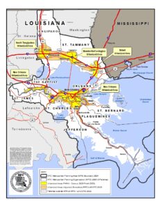 The Metropolitan Planning Organization (MPO) serves the urbanized areas of southeast Louisiana. This jurisdiction includes all or part of nine parishes: Jefferson, Orleans, Plaquemines, St. Bernard, St. Charles, St. James, St. John the Baptist, St. Tammany, and Tangipahoa.
Regional transportation system within the region emphasizes the coordination of travel and freight beyond just local streets, city limits, or individual parishes to ensure connectivity and ease of flow.
Key components of the regional transportation system include:
Highways and Major Roads: Connect cities and towns within the region and link to interstate systems.
Public Transit: bus lines, street cars, ferries, commuter busses, or ferries that serve or connect multiple jurisdictions.
Freight: Railroads, ports, and highways that facilitate the flow of commercial goods.
Airports: Regional airports that support passenger and cargo flights.
Bike and Pedestrian: Regional bike trails and pedestrian pathways connecting communities.
Intermodal Connections: Facilities where travelers can switch between modes
Why is Metropolitan Transportation Planning Important?
The Metropolitan Transportation Plan is essential because transportation systems—like roads, buses, trains, and bike paths—cross municipal and parish boundaries and impact entire regions. Planning at a regional scale ensures that transportation investments and policies are coordinated, efficient, and aligned with broader economic, environmental, and community goals.
What are the Goals of the MTP Process?
- Improve mobility and accessibility.
- Promote sustainability and environmental stewardship.
- Enhance safety and security.
- Support economic vitality.
- Maintain and modernize current infrastructure.
- Promote fair distribution of resources to meet the needs of users.
- Align transportation planning with other regional planning efforts.
- Foster innovation and technology.
What is the MTP Planning Process?
Existing Conditions and Needs Assessment
 A comprehensive analysis of the current state of the region’s transportation system. This serves as a baseline for identifying needs, challenges, and opportunities for improvement, and informs the development of future transportation strategies and investments.
Future Conditions
 Forecasted changes in demographics, travel needs, travel patterns, changes in land use, infrastructure needs, and environmental impacts over a long-term planning horizon.
Prioritization
 Evaluating existing conditions, needs assessments, regional trends and available resources in comparison with regional goals; prioritization guides resource allocation plans and programs.
Strategies
 Are broad action steps developed from regional priorities that guide transportation system investments, project development, and process for evaluating effectiveness of investments.
Planning Components
![]() Performance Measures
Performance Measures
![]() Traffic Management
Traffic Management
![]() Transportation Modes
Transportation Modes
![]() Demographics
Demographics
![]() Housing
Housing
![]() Economic Development
Economic Development
![]() Workforce Development
Workforce Development
![]() Environment
Environment
![]() Safety
Safety
![]() Reliability
Reliability
![]() Accessibility
Accessibility
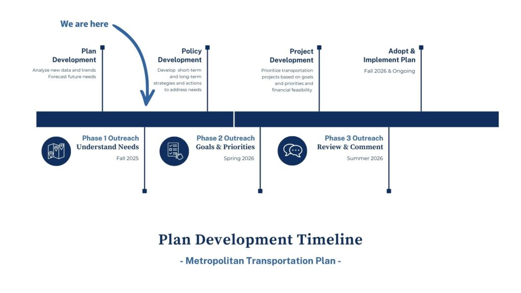
Timeline – when and how roadmap
Coordinated Planning and Engagement
“The MTP is a shared vision for the future of our region’s transportation system. We are committed to a transparent, inclusive, and collaborative planning process that reflects the needs and priorities of the entire community. Public engagement is at the heart of this process—your input helps shape the policies, programs, and projects that will guide transportation investments for the next 20+ years. Whether you walk, bike, drive, ride transit, or move goods, your voice matters. Together, we can build a safer, more connected, and more equitable transportation future.”
 Government Coordination in the MTP process is essential to ensure that transportation planning is cohesive, efficient, and aligned with the broader goals of all levels of government. Since transportation systems affect and are influenced by many sectors—land use, housing, environment, economy—strong intergovernmental collaboration is legally required and practically necessary.
 Stakeholder Coordination is central to the development the MTP. Understanding that transportation decisions impact all aspects of community life—from access to jobs and education, to environmental quality and economic opportunity. That’s why we are committed to a transparent, inclusive planning process that actively involves a broad range of stakeholders, including, transportation planning agencies, regional planning partners, business leaders, environmental advocates, and community-focused organizations
 Public Engagement The MTP aims to create a safe, accessible, and efficient transportation system for users within the region. Public engagement is a vital part of this process. We are committed to involving community members from all backgrounds—residents, commuters, business owners, and advocates to better understand the transportation needs for the region.
Through surveys, open houses, workshops, and online tools, we will provide opportunities for the public to learn, ask questions, and share ideas. The voice of the community ensures that the MTP responds to user needs and priorities.
Common Questions and Answers:
A1: An MPO (Metropolitan Planning Organization) is a regional agency in the United States responsible for transportation planning and decision-making in urbanized areas with populations of 50,000 or more. MPOs were established by federal law to ensure that federal transportation funds are used effectively and meet the needs of communities.
A2: Key elements of a Metropolitan Transportation Plan include the following:
A Metropolitan Transportation Plan (MTP) is a long-range planning document that outlines the transportation vision, goals, and strategies for a metropolitan area over a 20-year or longer time horizon. It is developed by a Metropolitan Planning Organization (MPO
Federal law requires MTPs for urban areas over 50,000 in population as a condition for spending federal highway and transit funding. MTPs must:
- Forecast for demand for transportation facilities and services for 20 or more years
- Identify policies, strategies, and projects that are recommended for the future
- Include both short-range and long-range strategies and actions that lead to the development of an integrated multi-modal transportation system
- Contain reasonable cost estimates for identified capital investments and operations and maintenance
- Be updated every 4-5 years
1. Long-Term Scope
-
Covers a planning period of at least 20 years into the future.
2. Multimodal Approach
-
Includes roads, transit, rail, bicycles, pedestrians, and increasingly, emerging technologies (e.g., EV infrastructure, smart transportation systems).
3. Financially Constrained
-
Must demonstrate that proposed projects and improvements can be funded with reasonably expected revenues (i.e., it’s not just a wish list).
4. Public and Stakeholder Involvement
-
Requires public input and engagement of various stakeholders, such as local governments, transit agencies, and the public.
5. Supports Federal Goals
Aligns with federal planning performance measures, such as:
- Economic vitality
- Safety and security
- Accessibility and mobility
- Environmental sustainability
- Efficient system management
6. Data-Driven Decision Making
-
Uses models and data (e.g., traffic forecasts, population growth) to assess future transportation needs and impacts.
A3: The planning process for an MTP is a structured, collaborative, and federally mandated effort based in Performance Based Planning and Programming using the following process:
- Analysis of Existing Condition
- Forecasting of Future Conditions
- Identification of Needs and Deficiencies
- Establishment of a Regional Vision, Goals, and Priorities
- Development of Strategies and Evaluation Techniques
- Financial Planning
- Draft MTP
- Adoption of an MTP
- Implementation and Monitoring
A4: MTPs are implemented through a combination of short-term programming, agency coordination, and continuous monitoring. While the MTP sets the long-term vision and priorities, implementation happens gradually over time, often in stages, through more detailed and short-term actions known as the Transportation Improvement Program.
The MTP guides which transportation projects get prioritized and funded in a region.
A5: Transportation Improvement Programs (TIPs) are short-term plans that outline specific transportation projects to be implemented over a 4-year period. TIPs consist of priority lists of projects (both highway and transit) which are being advanced toward construction. Projects found in the TIPs have evolved through the transportation planning process and are contained in the region’s long-range Metropolitan Transportation Plan covering the first four years.
A6: Both the regional TIPs and State TIP are identical documents containing a common set of projects proposed for federal funding. TIPs and STIP are products of a consensus-building process carried out jointly by the RPC and the Louisiana Department of Transportation and Development.
Both the TIPs and STIP are on a two-year update cycle. However, the TIPs are reviewed annually by the RPC and selected revisions are permitted, following formal amendment procedures.
Projects contained in the TIPs are derived from Phase I of the Metropolitan Transportation Plan. Projects are largely reconstruction-oriented consisting of roadway rehabilitation, overlay, and traffic signalization. Along with intermodal facilities development, bus transit and rail rehabilitation and extensions are also emphasized along with intermodal facilities development.
Projects identified in the TIPs are part of the approved Transportation Plan and refer to improvements being funded under the Infrastructure Investment and Jobs Act.